KOLKATA – LAND OF THE GODDESS KALI
INTRODUCTION
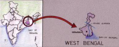
Calcutta, bengali kalikata, is the capital city of west bengal, in india (after 1912). it was the former capital (1772 -1912) of british india. the city boasts being the nation’s largest metropolitan in area.
Calcutta is located on the eastern bank of the hooghly river, an arm of the ganges, about 96 miles (154 km) Upstream from its mouth at the head of the bay of bengal.
This river port is the most important urban center of eastern india .


Although calcutta is favourably located for trade, its low, swampy, hot, and humid riverbank location is not ideal for human habitation. eastward from the river the land slopes away to marshes and swamplands. similar topography on the western bank has confined the metropolitan area to a strip 3 to 5 miles (5-8 km) wide on either bank, although reclamation projects have expanded the limits of usable land to the east, south, and west of the central city.

EVOLUTION OF KOLKATTA
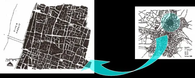
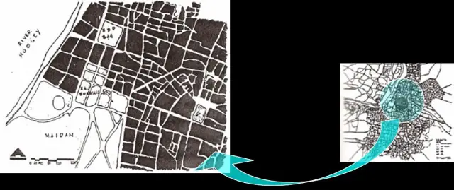
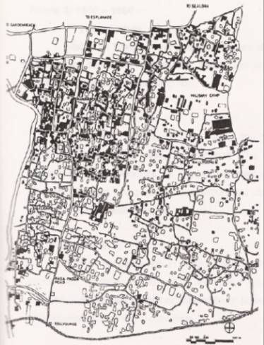
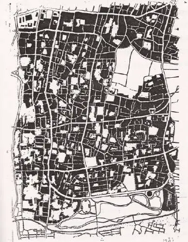
KOLKATA 1690
- In the year 1690. job charnock, a company agent and chief of english factory established the important centre for trade and commerce in sutanuti village on the eastern banks of the river hooghly.
- This was the origin 0f the city of calculta.
- During this time the villages by connected by a route from chitpur in the north to the kalighat temple, that was built in the 15th century, in the south. the english bought gobindapur, kalikata and sutanuti villages to establish their settlement.

- The first major step they had taken in the procell is to shift the bengalis from thearea around the present dalhousie square to further north because of the strategic location to build the fort for their security.
- The battle of plassey in 1757 was in a way a turning point for the growth of calcutta.the supremacy of english in bengal was established.
- It was transforming itself from purely garrison town to an administrative cum culture centre.

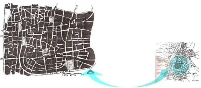
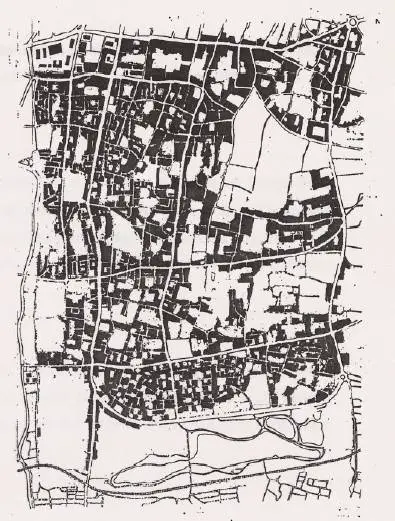
KOLKATA 1852-56
- The great tank of dalhousie square was developed as an administraative centre.
- The maratha ditch got converted to be the circurlar road all along the city as a cityboundary till the mid 19″ century.
- The area, which is south 0f the maratha ditch, was full of ponds and ditches ,spreads of jungles or ‘ hogla’ trees.
- In the southern part it was mostly the englishmenand the rich businessmen who started building up houses.

- The british decided to shift the capital from calcutta to delhi in order to control theirterritory more from a central position of the empire.
- The capital got shifted in 1912 ad, and soon the british government set up theimprovement trust for the settlement of living condition in the city.
- The only directions for calcutta’s growth were east and south. north was already , congested and west was the river.

The urban settlement of kolkata can be defined in to three definite regions, which can be broadly distinguished according to history, socio-economic culture, and architectural character.
NORTH KOLKATA : neighbourhoods of elite bengalis, crafts men, artisians and traders.
CENTRAL KOLKATA : the business district developed by the british with palatial structures used as residences for british officers.
SOUTH KOLKATA : neighbourhoods of upper middle class bengalis
NORTH KOLKATA
LOCATION
- North kolkata lies to the north of esplanade (public pathway) on the eastern banks the river.
- It is built in the area where there existed the village of sutanuti.
URBAN STRUCTURE
- North calcuta has low height buildings with maximum of ground coverage.
- The buildings are all attached to each other and have practically no side setbacks.
- Typical roadside buildings have car porticos (‘garibaranda”) highlighting the building entrance.
- Open space is less in this part.
STREET PATTERN
- Streets in north kolkata can be categorised into three types, they are roads, lanes and by-lanes.
- This division is basically on the basis of the road width and also on the kind of activities happening.
PUBLIC SPACE
- North kolkata has the least number of public open ‘spaces’.
- Parks are used for recreational purposes by the locals.
- Street corners and roadside tea stalls are mostly used as public SPACES.
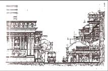
CENTRAL KOLKATA
- It is established on the site of the gobindapur village.
- Central kolkata is mostly covered between esplanade and the park street and is stretched till the lower circular road as its limits.
- It is the administrative and the commercial district of the city.
- Monumentals scale in proportion.
- The administratlve district along the four sides of the great tank, has a resemblance of london.
- The british have not done any compromise in their city road layouts.
- Visiting planner. drew on what theyknew of the west and their work inevitably reflected the planning
- theories and design guidelines that had arisen in tne western context.
STREET PATTERN
- Main roads are wide carriage ways and are laid straight, which act as vistas.
- Even the lanes in these areas where mostly the europeans have settled are wide enough for vehicular movements.
PUBLIC SPACE
- Central kolkata has designed public open spaces.
- The open space of the great tank creates an ambiencs of the area.
- The other one is the biggest open space of the city, the maidan.
URBAN STRUCTURE
- The southern parts 0f the city are preplanned and have a definite control over the urban form.
- The buildings here are having proper setbacks on all the four sides. tn some old areas in bhowanipore and kalighat Buildings have come up right on the street edge.
- It has a mix of some old kolkata and some new type of architectural style.
- This part 0f the city is moslly residential except some large markets, which has been planned to cater the needs 0f the people living here.
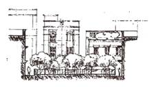
SOUTH KOLKATA
LOCATION
- This part of the city extended to the eastern wetlands and to the river in the west.
- South kolkata is defined by the region, which lies to the south of the lower circularroad.
URBAN STRUCTURE
- The southern parts 0f the city are preplanned and have a definite control over the urban form.
- The buildings here are having proper setbacks on all the four sides. tn some old areas in bhowanipore and kalighat Buildings have come up right on the street edge.
- It has a mix of some old kolkata and some new type of architectural style.
- This part 0f the city is moslly residential except some large markets, which has been planned to cater the needs 0f the people living here.
STREET PATTERN
- Streets in these areas are planned, are wide enough for vehlculr movements.
- The lanes and by lanes are Again have the feelings of north kolkata in some parts while in other parts, where they have been planned, they are wide enough to make it vehicular.

PUBLIC SPACE
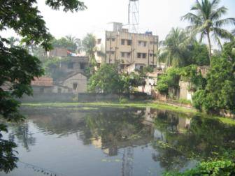
- South kolkata has a quite a few number of open spaces.
- It also has a huge open space in rablndra sarobar .
- Roadside tea stalls and street coners are actively oriented.

EVOLUTION OF SOUTH KOLKATA (1900-1920)
The only directions calcutta could grow were east and south. north was alreadycongested and west was the river. as far as east is concerned the scope to expand was again limited due to the wetlands. the only direction open for growth was south.
PHYSICAL FEATURE
- The soulh suburb was a swamp filled with ditches and jungles
- Tolly’s nala was cleared and made navigable b the efforts of a british officer
PEOPLE
- Mostly comprised of europeans and parsis near the southern edge of the lower circular road.
- The bhowanipore area housed upper middle class bengalis, whose lifestyle was under the influence of the europeans.
SPATLAL FORM
- The main road to south is leading to tollygunj passing through kalighat and manoharpur that had very sparse se!llements.
- The kali temple at kalighat built in the earty sixteen hundreds was the prime focus within the area and visited by people from all over for religious purpose.
- Military camp in ballygunj and a weekly market in gariahat.
ARCHITECTURE
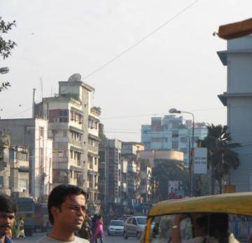
- Most of the built structures of the europeans and the parsis were three to four store high palatial mansions near the lower circular road.
- Bengali residences were single i double storey structures having verandahs facing the roads with long corridor. and inner courtyards at the back.
PLANNING PROPOSALS
Shift of the capital from calcutta to delhi in 1911. Formation of calcutta improvement trust to prepare schemes for improvement of existing areas and for planned future developments.
EVOLUTION OF SOUTH KOLKATA (1920-1940)
PHYSICAL FEATURE
- The receding wetlands in the south and in the east were reclaimed.
- The swamps and layouts of areas and roads earmarked for development.
- City started digging up of the lake rabindra sarobar.
PEOPLE
- Upper middle class bengalis started moving into the new areas.
- A mixed lifestyie that was influenced by british education was reflected in the courtyard houses of south calcutta.
SPATIAL FORM
- Gariahat, kalighat and “jadu babu’s” bazaar led to the establishment of full-fledged markets in these areas.
- Development mainly occurred in the areas of bhowanipore. manoharpur. on either side of rashbehari avenue and ballygunj.
- New road layouts were also laid out during this period.
ARCHITECTURE
- Plan form of the buildings were mostly symmetrical.
- Residences in south calcutta had large setbacks on all sides.
- Building materials mainly used was brick and lime-surkl
- Wooden beams were used for structural support.
- Decorated wrought iron railings we’re used in verandahs for residential buildings.
PLANNING PROPOSALS
- Wider implementation of the city sohemes prepared in 1913.
- North edge of rabindra sarobar was the last city municipality proposed.
EVOLUTION OF SOUTH KOLKATA (1940-1960)
PHYSICAL FEATURE
- Rabindra sarobar and other tanks were developed.
- More of land reclaimation laid to further receding of the wet lands towards the south.
PEOPLE
- Evolution of neighbourhoods through activities like ‘baroan’ durga puja, involved greater community participation.
- The calcutta rowing club, football stadium and parks for recreation that came up during this period showed an increasing inftuence of europaan lifestyfe.
SPATIAL FORM
- Densification along the major roads like, rashbeharl avenue. lansdowne road, hazra road, gariahat road and asutosh mukherjee road.
ARCHITECTURE
- There was lesser elaboration and ornamentation of buildings. Decreasing plot sizes due to fall in economic condition of people led to very less setbacks.
- Courtyard houses with long corridors gave way to smaller houses with lesser setbacks
PLANNING PROPOSALS
- No new planning and development schemes were formulated for south calcutta.
- Greater part of planning activities was confined to the central calcutta.
EVOLUTION OF SOUTH KOLKATA (1960 ONWARDS)
PHYSICAL FEATURES
- Major road layouts were planted with trees along the edges.
- Development of parks & playgrounds took place for recreational purposes
SPATIAL FORM
- Construction of high-rise apartments along southen avenue and other major roads lead to densification .
SOCIAL
- Post partition influx of refugies laid to mushrooming up of slums.
- These labour class people in the slums earned daily wages through grueling hardwork.
- Multi-storied apartments cause lesser interaction among the people.
- Neighbourhoods got limited to one multi-storied building only.
ARCHITECTURE
- The concept of individual ownership changed to flat ownership kind.
- Commencement of architectural education in the technical institutes like the bengal engineering college and jadavpur university strengthened propagation of contemporary architectural concepts of the west.
- Cement replaced earlier used lime surki as building materials .
- Thus load-bearing structures are replaced by frame structures.
PLANNING PROPOSALS
- Calcutta was aiso affected by the countrywide interventions in planning.
- In 1961, the calcutta metropolitan planning organisation (cmpo) was formed.
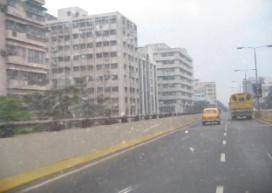
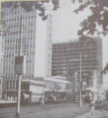
THE TRAFFIC AND TRANSPORTATION ILLS OF CALCUTTA
The large growth that has occurred in calcutta has made it increasingly more difficult to maintain acceptable levels in urban services, and in recent years most urban services have actually deteriorated.
Transportation services are among the most severely affected.
The impact due to population growth alone has been compounded by increased rates of usage for both public and private transportation brought about by the effect of improved personal income levels in increasing desires for personal mobility.
![]()
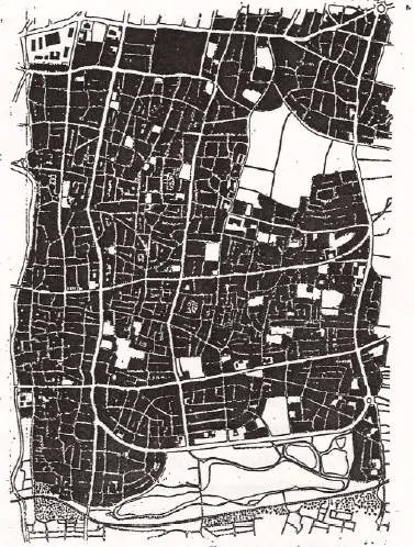
For the purpose of system classification,three general categories of roadways were established,based upon traffic function.
The first group,referred to as local streets,serves the most basic function-property access-and as such is expected to serve only traffic destned to locations along the allignment of such roads.
At the opposite extreme in terms of function are facilities designed to serve only traffic movement. in order to ensure that this function is properly served,these facilities,known as expressways,have no provision for direct access to abutting property and are developed to very high standards of design.
Streets making up the third and final category are known as arterials.these have dual function : they serve through-traffic movement as well as provide access to abutting land.
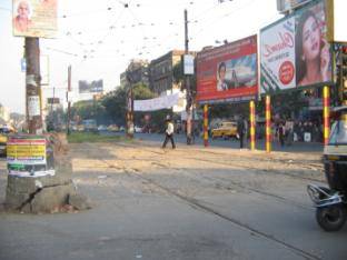
In central calcutta a grid pattern of arterial streets is recognisable but in other parts of the area, roadway development has been haphazard.
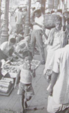
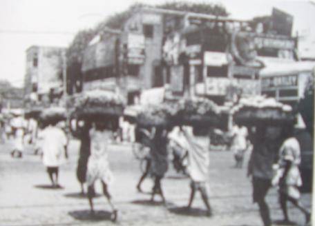
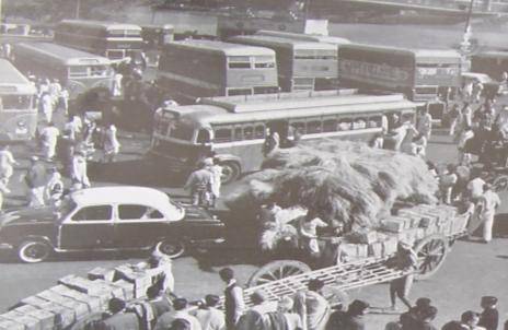
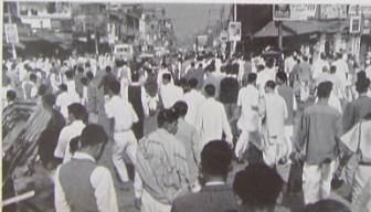
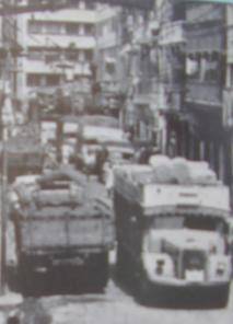
When footpaths become food and clothing markets and customers occupy a second line of space- then pedestrians are forced to take to the streets. periodically the footpaths may be cleared of hawkers- but they return because there is no organised effort to provide them with other low – cost space. many of the hawkers are migrants who would otherwise have no way of making even a meagre living.
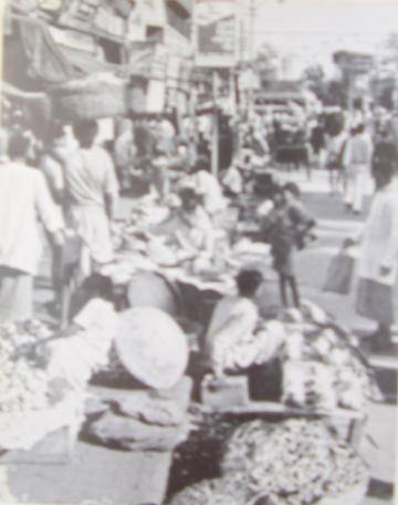
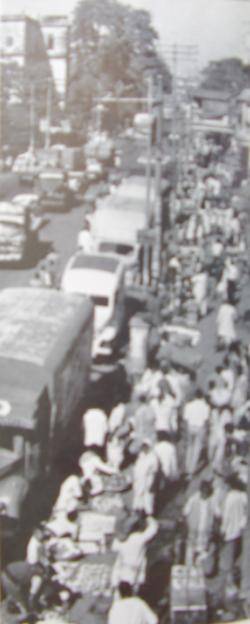
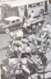
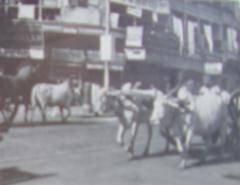
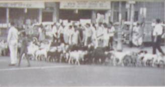
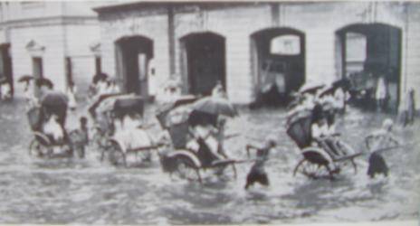
Slow moving traffic that contributes to streets congestion: handcarts with heavy loads pushed and pulled;horse –drawn garries-poor man’s taxi; the head- load carriers bearing vegetables from the railway stations ; animal traffic like bullock- carts and a troop of goats on the way to grazing on the maidan. besides these, man-pulled ricksaw, of which there are thousands in the city and which perform their greatest service during the rains, when streets are flooded because of poor drainage.
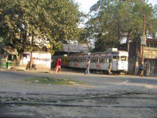
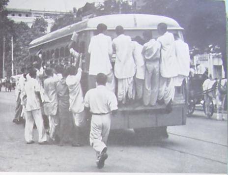
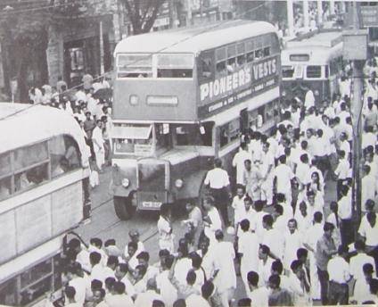
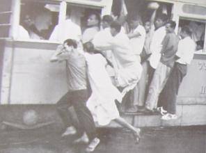
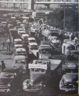
Surface transport is the only public transit in calcutta. the 400-odd trams that daily ply on 42 miles of track in the city are greatly overloaded in rush hours.they often carry as many as 200 passengers, when their seating capacity does not exceed 80.
![]()
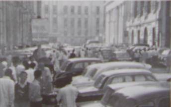
Both tram and bus fleets, which total only 1,400 for the city of 30,00,000 that has a daily increase of thousands of commuters, are therefore acutely uncomfortale in rush hours and passengers often risk loss of life of limb as they cling to the outside of the vehicles.
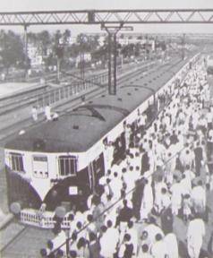
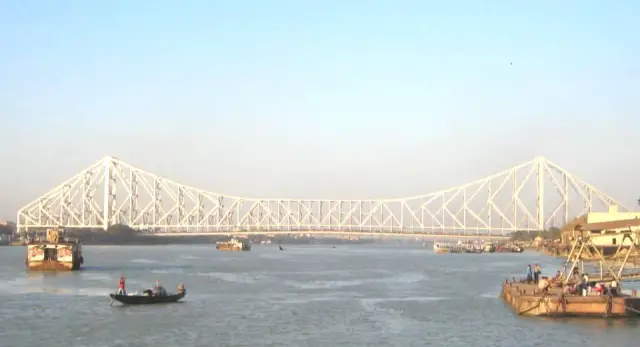
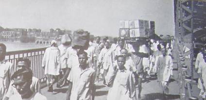
HOWRAH BRIDGE : 1,25,000 pedestrians crossing a day…35,000 fast moving vehicles…another 15,000 slow vehicles, plus stray and attended animals. ths mixed and uncontrolled traffic over the bridge and at the howrah railway station, and on the bridge approaches, makes crossing on the hoogly an unpleasent experience.
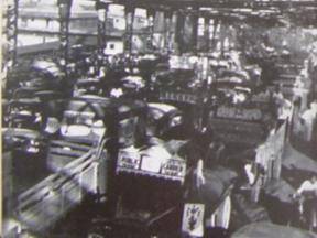
Need for traffic control and traffic safety education is plain to see on any week day. the outpouring of passengers from the main railway stations can fill street intersections for minutes at a time. policemen, phasing crossing intervals by observation at their immediate station, cannot carry out efficient controls that would be simplified by synchronized signalization.
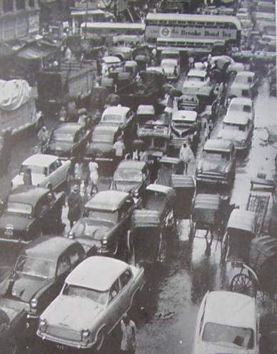
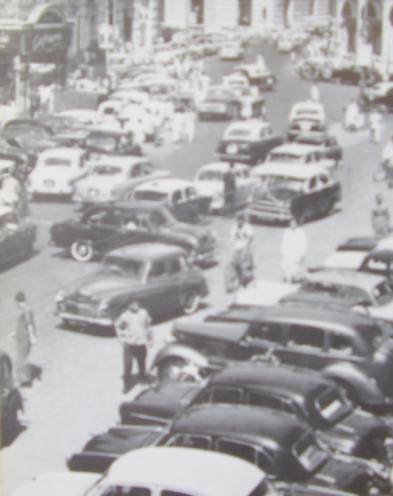
Automobile parking in calcutta must soon come to grips with the facts: kerb – parking diminishes too much of the needed street space for moving traffic…rising new skyscrapers, both office and residence, require provision for off-street parking… lack of terminals for the goods trucks coming into the city results in a virtual taking over of streets at times.
Leave a Reply
You must be logged in to post a comment.