Jaipur lies at a distance of about 200 miles from Delhi, 150 miles from Agra and 84 miles from Ajmer. Capital city of Rajasthan is located amidst the Aravali hill ranges at an altitude of about 430 m above sea level.
- Latitude – 26 55’
- Longitude – 75 50’
Map Showing Jaipur in Eastern Part of Rajasthan
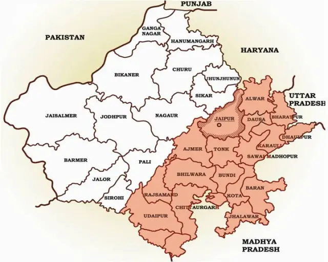
The eastern Rajasthan, lying to the east and south east of the Aravalli divide includes the modern administrative districts of – Udaipur, Chittorgarh, Rajsamand, Banswara, Dungarpur, Kota, Bundi, Baran, Jhalawar, Bhilwara, Ajmer, Jaipur, Tonk, Dausa, Dholpur, Karauli, Bharatpur and Alwar.
The current district of Jaipur lies in Eastern Rajasthan, in the Banas River basin and forms a part of Eastern Plain of Rajasthan. The region is drained by a number of seasonal rivers of which Banganga, Dhundh and Bandi are prominent.
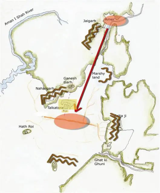
From the 10th century onwards, the district referred to as Dhoondhar, formed one of the four distinguishable politico-cultural regions of Eastern Rajasthan, in addition to Mewat, Hadauti and Mewar. Dhoondhar region was roughly comprised of current districts of Jaipur, Dausa and Tonk, with Jaipur and Amber further constituting Dhoondhar subzone within the larger tract of Dhoondhar region.
In Aryan epics, Dhoondhar region (called Matsya Desh/ Mina Wati) was the shortest trade route between north India and rich port cities of Gujarat and Malabar. The region was held by Badgujars, Rajputs and Minas till the 11th century.
From the 11th century onwards, however, the Dhoondhar region was increasingly under the power of Kachchwaha dynasty of Rajputs.
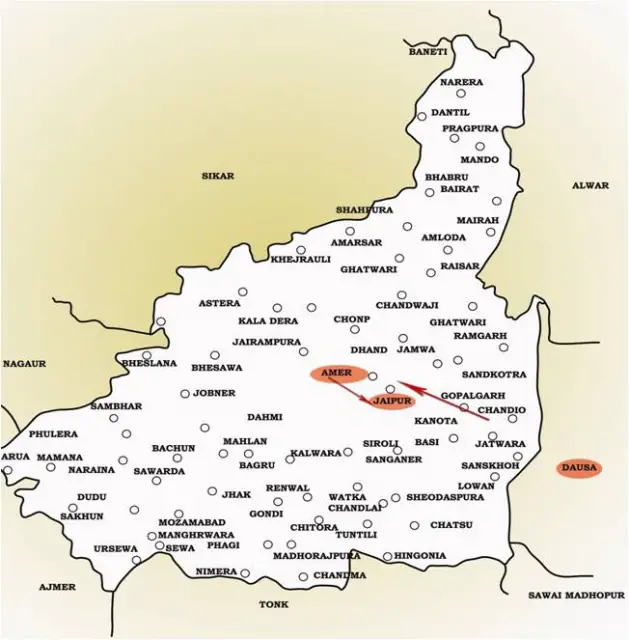
Reasons for Maharaja Sawai Jai Singh to change his capital from Amber to Jaipur:
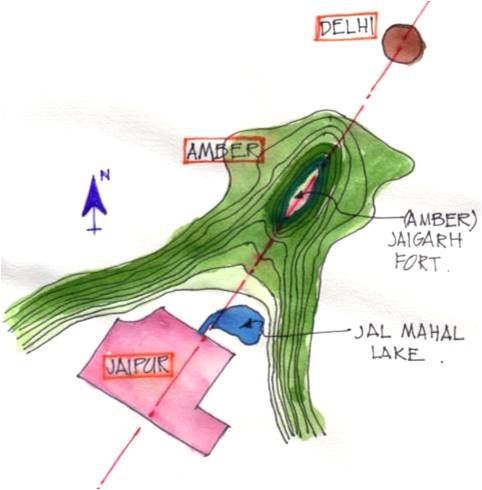
- The rocky terrain of Amber restricted expansion.
- Jaipur had the potentialities of developing into a city with adequate drinking water due to the presence of a perennial stream nearby and good drainage system. Its rugged hills also ensured a constant supply of building material, which might be required in the times to come
- The need of a new capital for 18th century Dhoondhar as the earlier one of Amber built on a hill was getting congested.
- Sawai Raja Jai Singh’s vision of the new capital as a strong political statement at par with Mughal cities and as a thriving trade and commerce hub for the region.
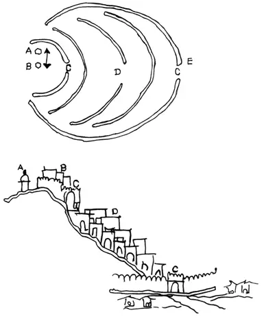
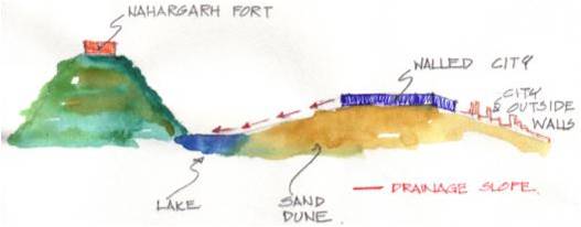
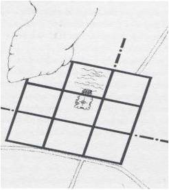
The generic plan of a medieval Rajasthani hill town- as in Dausa and Amber (TOP)
The hill town of Dausa with an organic layout guided by the topography (BELOW)
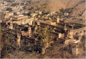
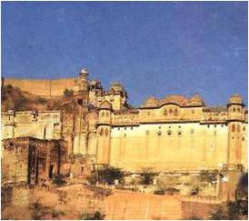
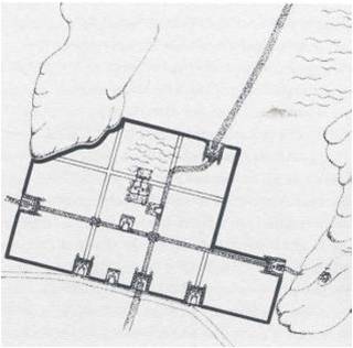
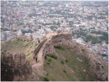
Amber Town with the Fort on top of the hill and the walled town down the slopes
- The medieval towns of Rajasthan were of military, agrarian, mercantile or religious nature. The presence of a deity marked the reference point for the ruler’s abode and the rest of the city. The name of the town was usually associated with the political or religious centre (with the Ambikeshwar temple in the case of Amber and with Sawai Jai Singh in the case of Jaipur).
- Unlike Dausa and Amber, the two previous capital cities of the Dhoondhar region established on hill-top, whose planning was guided by topographical structure of the areas, Jaipur city was revolutionary both in terms of its grid-iron pattern planning and its location at the base of the hills.
- There was also a significant economic shift from an agricultural base in Dausa and Amber to trading in the capital of Jaipur.
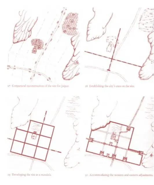
- The layout of the city of Jaipur wonderfully links the concept of a Shastric city with the practicalities of the chosen site.
- First, the straight line of the ridge suggested itself as the route for one of the main east-west thorough fares and building a road along its crest makes best possible use of the topography for the purpose of drainage.
- What followed then was to regularize the Amber-Sanganer road as a north-south route at right angles to it.
- The point of intersection would be one of the city’s main cross-roads (chaupar)
Although the location of the axes was determined, their extents were yet to be defined. The southern boundary of the city had to lie within the line of the Agra-Ajmer road. So by extending the NS road as far as possible southwards gives the first fixed dimension, the length of a side of a square and so establishes the size of the unit or module of the city.
A hunting lodge known as Jai Niwas. It was the king’s wish that this establishment come within the city.
A road cutting the plain from N to S linking Amber,the capital to Sanganer, the principal trading town. This road had to be preserved and controlled and therefore had to fall within the city’s boundaries
A second road ran E to W between the Mughal cities of Agra and Ajmer and placing the new city on this already established communication line would help secure its economic success. However since this was an imperial road that could not be encroached on, thus the city had to be contained to the north of this line.
Also, a natural ridge runs across the plain, N of the road and parallel to it, in a roughly EW alignment (with a slight deviation of15 deg. from the cardinal axes). The area to its S is flat while that to its N slopes down gently. In Shastric terms, this is an ideal arrangement as declivity towards the north-east Is considered the best site. In practical terms, the ridge too had to be accommodated.
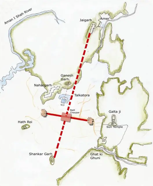
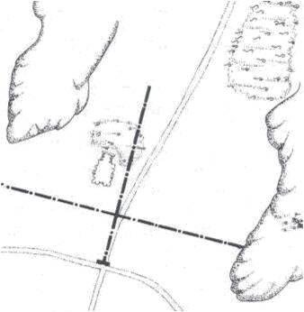
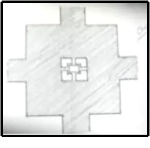
The intersection of the axes to define the Badi Chaupar (City Square).
Division in to eight portions, ends of the roads marked by Gates in the City Wall
CONCEPTUAL PRASTARA PLAN
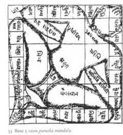
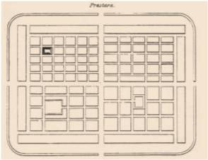
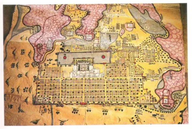
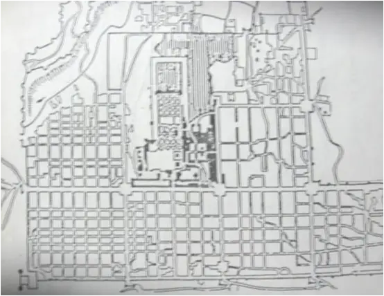
- It is a model of town planning- the first planned city in India. It is based on Hindu systems of town planning and followed the principles prescribed in the Shilpa-shastra, an ancient Indian treatise on architecture .according to this shastra the site should be divided into grids or mandalas rangung from 2x 2 to 10 x 10.
- Planned according to the Prastara type of layout, which gives prominence to the cardinal directions.
- Thus plan of jaipur is a grid of 3×3 with gridlines being the city’s main streets.
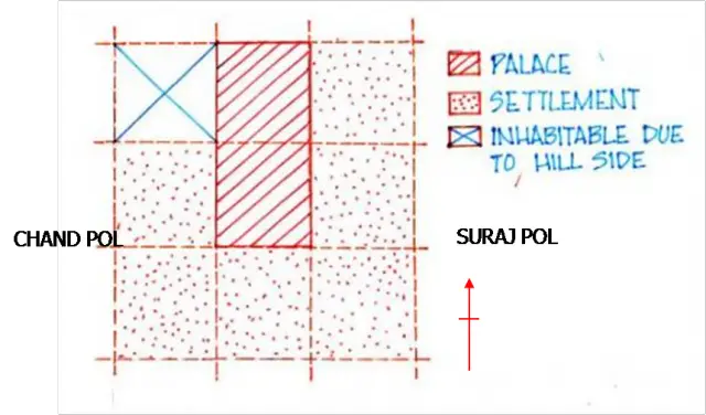
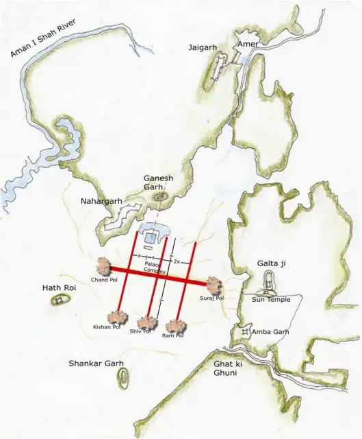
- The central axis of the town was laid from East to West between the gates of the Sun(Suraj pol) and the moon(Chandpol)
- This was crossed by two roads at right angles dividing the town into nine almost square, almost equally sized blocks, which were further sub divided by lanes and alleys all at right angles.
But by building the western boundary of the city right up to the hill’s southern apex, it provided a continuous line of defense.
The mandala could not be complete in the NW due to the presence of the hills.
On the other hand in the SE an extra square has been added that plugged the gap between the city and the eastern hills.
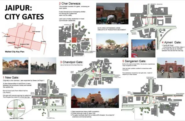
The town has around it a masonry wall, 25ft. high & 9ft. thick, with eight gates.
The gates are:
- Chandpole Gate,
- Ghat Gate,
- Ajmeri Gate,
- Sanganeri Gate,
- Surajpole Gate,
- Gangapole Gate,
- Zorawar Singh Gate,
- and New Gate.
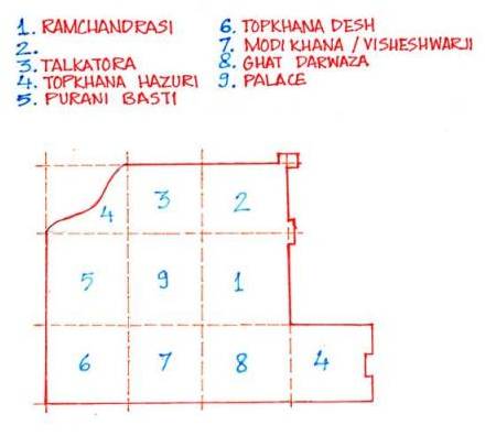
- The palace building covered two blocks, the town six and the remaining ninth block was not usable on account of steep hills. So this North-West ward was transferred to the South-East corner of the city, making the shape of the plan as a whole asymmetrical rather than square.
- The city’s division into nine wards was also in conformity with the Hindu caste system, which necessitated the segregation of people belonging to different communities and ranks.
- Even the lanes were named after the occupations of inhabitants such as Maniharon ka Rasta, Thatheron ka Rasta & many others.
- Following the directions of the Hindu Shilpa shastra, width of the main streets & other lanes were fixed. Thus the main streets of the city were 111ft. wide, secondary streets 55 ft. wide & the smaller ones 27ft. wide.
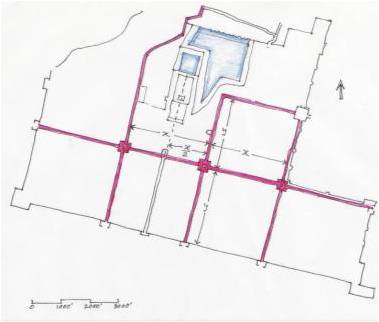
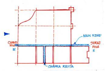 South of the main road were four almost equal rectangles. The rectangle opposite the palace has been broken up into two equal and smaller rectangles by the Chaura Rasta.Thus altogether there are now five rectangles on the south of the main road called Chowkris.
On the North of the main road from West to East are the Purani Basti, the Palace and Ramchandraji.
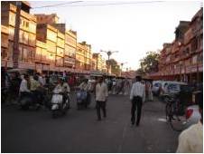
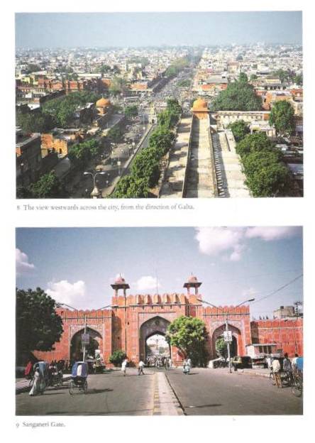
The principal bazaar leads from the western gate in the city wall, The Chandpole, passing in front of the Tripolia Gate, to the eastern city gate, the Surajpole.
- To the NW of this lay the Jai Niwas. Given that its royal association meant that it had to be within the palace compound, the site of the palace was established. Indeed, given the wish to locate the palace centrally, the position of the brahmasthana was also established. A wall surrounds the palace buildings.
- The serving class occupied the peripheral areas.
- Another constraint was the position of the lake, which formed a part of the pleasure garden around which the city was built. This lake lay close to the hillside. In the original design it fell outside the main block of the city; but due to Jai Singh’s wish to include the old garden in the city, the lake was made the tank of palace garden.
PICTURE IN BRIEF
URBAN FORM AND ARCHITECTURAL IDENTITY
WHY PINK?
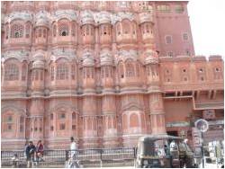
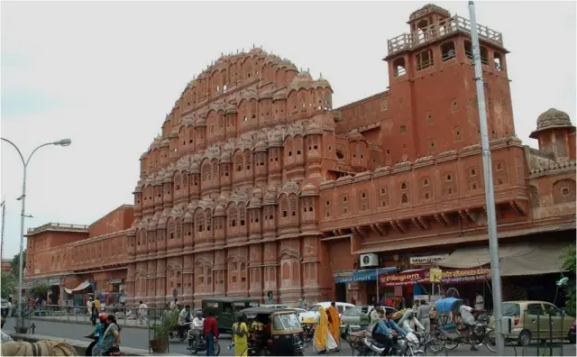
Jaipur is known as the Pink City, a rather idealized description of the terra-cotta-colored lime plaster that coats the old part of the city’s walls, buildings, and temples.
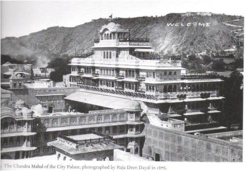
The reasons for painting the town pink are unknown, but various theories have been tossed about, from using pink to cut down glare, to Jai Singh II’s apparent devotion to Lord Shiva (whose favorite color is reputedly terra cotta). Others believe Singh wanted to imitate the color of the sandstone used in the forts and palaces of his Mughal emperor-friends. The most popular reason (spread no doubt by “Britishers” during the Raj era) is that pink is the traditional color of hospitality, and the city was freshly painted and paved with pink gravel to warmly welcome Edward VII for his visit here in 1876.
- ROAD NETWORK
- Jaipur’s road network follows a definite hierarchy. The major east-west and north-south road ,form the sector boundaries and are called Rajmarg as they lead to the city gates. These measure 33m. wide.
- Next there is a network of 16.5m wide which runs north-south in each sector linking the internal areas of the sectors to the major activity spine.
- An orthogonal grid of 8.25mx4.00m roads in the prastara-chessboard pattern further divide sectors into Mohallas.
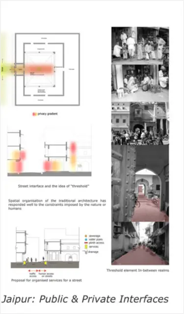
 PUBLIC SPACES
- Public spaces can be divided into
- Chaupars
- Bazaars
- Mohallas
- Streets
- Temples
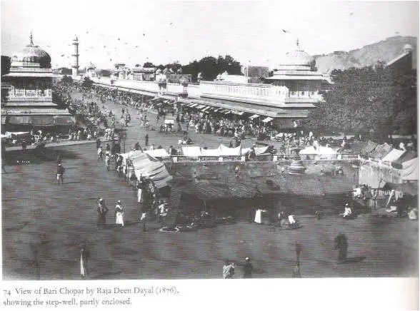
CONCEPTUAL PLAN – CHAUPAR
CHAUPAR – It’s a square that occurs at the intersection of east west roads with three north south roads. Each chaupar is around 100m x 100m. Were used for public gathering on festive occasions. The distance between two chaupars is about 700m which is ideal for pedestrian movement. It has controlled façade treatment enveloping it.
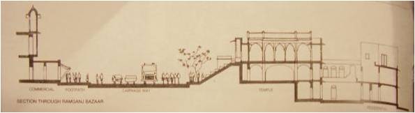
Section through Ram Ganj Bazaar
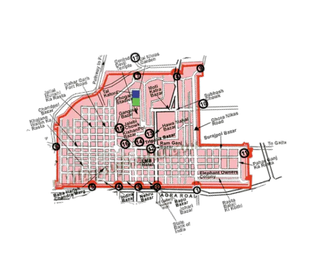
BAZAARS – Originally only four bazaars were planned for the city. These were later named as Johri bazaar, Sireh Deori Bazaar, Kishan pole Bazaar & Gangori Bazaar
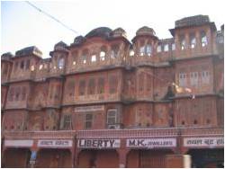
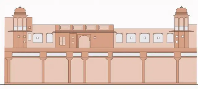
On the main streets strict control was exercised on the street façade, along which were located shops and arcades- one storey high, but beyond the frontage the buildings could be of any height or any shape, some built with flat roofs & others with traditional chattris.
URBAN FORM AND ARCHITECTURAL IDENTITY
- STREETSCAPES AND CHOWKS
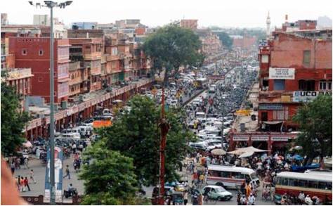
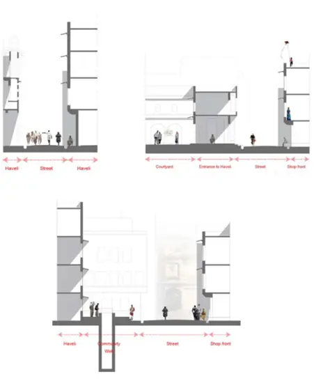
View (above) of a main bazaar street – the width of the main roads was kept 39 1/4 gaz – 108 feet, secondary roads are half this size – 54 feet, the tertiary roads are 27 feet and the inner mohalla streets are 13 feet wide.
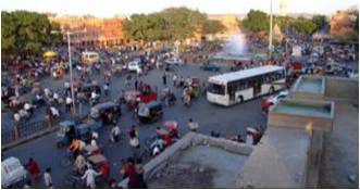
View of a chaupar today
- The main markets, havelis and temples on the main streets in Jaipur were constructed by the state in the 18th century, thus ensuring that a uniform street facade is maintained. The widths of roads were predetermined.
- According to a popular belief, the city was painted pink to celebrate the visit of the Prince of Wales in 1876, during the reign of Maharaja Sawai Ram Singh II, lending the city the name of ‘Pink City’.
- Junctions of the main axial streets formed the two square civic open spaces called chaupars (Badi chaupar and Chhoti chaupar). The width of the square chaupars was three times that of the main street.
- Historically, the chaupars were outlets for intense social use with water structures connected by underground aqueducts, supplying numerous sources of drinking water at street level. Presently, the centre of each chaupar has square enclosures with ornamental fountains.
- The streets and chowks (central open squares in a town) of the internal chowkries (sectors) with numerous clusters or mohallas were not predetermined; hence show a mix of grid iron and organic pattern, with the basic unit of built form being the rectangular haveli.
URBAN FORM AND ARCHITECTURAL IDENTITY
- BAZAARS
- Original markets in the city include Kishanpole bazaar, Gangauri bazaar, Johari bazaar, Sireh Deorhi bazaar, along the main north-south and east-west axes that intersect at Chhoti and Badi Chaupars.
- Typical architectural features of the bazaar streets are – use of chhajjas (sunshades) resulting in strong horizontal lines, projecting vertical blocks on brackets, a modular system of arches filled with delicate latticed screens to cut direct sun and glare of reflected sun in the street.
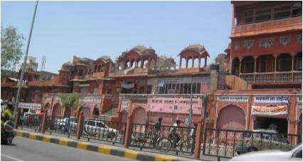
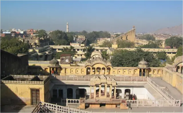
Bazaar streets have temples above shops with wide staircase starting from pavement to the temple level. Space above shops at first floor level originally functioned as galleries for watching royal processions, religious festivals and public celebrations
Uniform planned shop fronts on bazaar streets with upper floors in interesting juxtaposition.
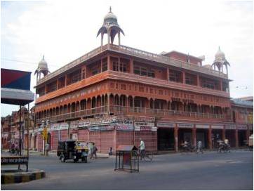
Defined street façade at a chaupar with sunshades and latticed colonnades at upper floors and shop fronts on the ground floor.
hey me a current student of
hey me a current student of 5th yr architecture,mumbai.
i was researching and understanding the development and evolution of the city jaipur(spl the walled city).
it was interesting to know how and why was the city planned.
the research is related to my thesis topic of “URBANIZATION AND OVEROBERNIZATION”. i required a little help regarding that. i wanted to have the DP plan of jaipur splz a vector map [autocad plan of city jaipur]. It will be really helpful if u can provide me with the plan and help to know where can i get it from.
i just required the plan so i assure u of the security and safety issue abt the research and project of urs..
thanks a lot hoping to receive a reply from u soon
IT WILL BE REALLY HELP IF I
IT WILL BE REALLY HELP IF I CAN REALLY GET THE AUTO CAD MAP OR VECTOR MAP OF THE CITY SPLZ ONLY THE WALLED CITY……
I M DOING A THESIS STUDY ON THIS PART OF JAIPUR AND I M IN NEED OF THE PLAN… plz can send me the plan or tell me where can i get it from plz
i ausre u of the safety and security abt it…
tanuj jain
5th yr B ARCH
MUMBAI
Your article Is a fantastic
Your article Is a fantastic piece of research and I thoroughly enjoyed reading it. If possible would you be able to share some of your research or any sources that you have found useful? I am currently designing a hypothetical urban intervention in Agra and I have been to Jaipur and was very impressed with its urban structure to the extent that I intend to use it as a case study. Any correspondence would be much appreciated.
Lee Hodgetts
Part 1 BA Architecture
London Metropolitan University
old jaipur case study!!!
old jaipur case study!!!